Data
Some of the maps we create for our publications are available here in the ARC file type “layer package” (extension .lpk). If you are interested in others, don’t hesitate to contact us.
_____________________________________________________________________________________
Ecosystem services research: This map is of Figure 2 from our paper and shows total ecosystem service values by tropical forests in America, Africa, and Asia and Oceania as predicted by our meta-analytic model. Please see the paper for additional details.
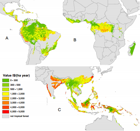
Carrasco, L.R., Nghiem, T.P.L., Sunderland, T., Koh, L.P. (2014) Economic valuation of ecosystem services fails to capture biodiversity value of tropical forests. Biological Conservation. 178: 163–170. Article PDF
_____________________________________________________________________________________
Bayesian deforestation models: These maps show the deforestation predictions of two different Bayesian models under three different deforestation scenarios. Some of these predictions appear overlaid on land use maps of Indonesia in Figure 3 from our paper. Please see the article for additional details.

Brun, C., Cook, A.R., Lee, J.S.H., Wich, S.A., Koh, L.P., Carrasco, L.R. (2015) Analysis of deforestation and protected area effectiveness in Indonesia: A comparison of Bayesian spatial models. Global Environmental Change. 31: 285-295. Abstract PDF
_____________________________________________________________________________________